Today and last Friday, my classmates and I learned about topographic maps and how many people use them to help their jobs. We drew a topographic map and answered questions.
What is topography?
The mapping of elevation/height.
What does a topographic map tell you, that other maps can't?
Topographic maps tells us the elevation.
Who might use a topographic map (and why?)
Geologists, Geographers, Marine Scientists and Farmers use topography maps to map the ocean and the land. Pilots and Firefighters use them for direction and direction of heat.
Define the following:
Elevation:
Height of a place relative to a reference height.
Contour Lines:
A line connecting points that have the same elevation.
Contour Interval:
The difference in elevation between two adjacent contour lines.
Depression Contour:
Contour lines that indicate a downward slope. It is drawn with hatch marks.
Practice Questions:
1) Which of the topographic maps shows two peaks? Map C
Which side has higher elevation? The left side.
2) Which topographic map shows the steepest cliff? Map B
Where is it?
It is the map on the right.
3) Can you tell the elevation of the topographic feature in plot B exactly? If so, what is the elevation, if not, why and what would be your closest guess?
No, I cannot tell the elevation of the topographic feature in plot B because it is not clearly labeled. In fact, it is barely labeled!
4) Which topographic map has a contour interval of fifty (50) feet? Map A
5) Which of the topographic maps depicts a canyon, or depression? Map B
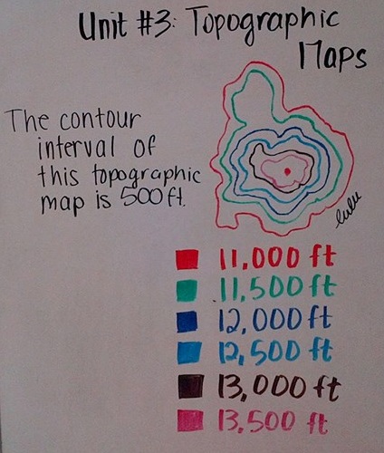
The topographic map you see on the right side of the picture is what my class and I focused on in class. I had cut and traced the map from paper onto whiteboard. "Whose whiteboard is this?" It's mine! I have a whiteboard at home and wellp. I wanted to do this on the whiteboard, instead of coloring. I was being lazy - didn't want to color. So I over-complicated things and yeep. Here is my drawing/picture on our work of topographic maps. As you can see, the lines are different colors, and underneath them, you'll see a "key" or a "legend" explaining/describing their contour-ness... Meh. (I had even written out the contour interval.. ;3 )
